


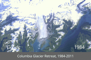
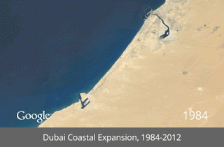
Google today announced that it has partnered with the US Geological Survey (USGS), NASA and Time and launching together a satellite-photo Timelapse tool, which means now you can go back in time and get a stunning historical perspective on the changes to the Earth’s surface over time. The search giant shared Dubai’s artificial Palm Islands, the retreat of Alaska’s Columbia Glacier, the deforestation of the Brazilian Amazon and urban growth in Las Vegas from 1984 to 2012.
Google says the images which were collected as part of ongoing joint mission between the USGS and NASA called Landsat. Started working together since 2009, results in make this archive of earth imagery available online. Google further added that using Google Earth Engine technology, a total of 2,068,467 images – a total of 909 terabytes of data being shifted – to find the highest-quality pixels possible.


